Map - Nueva Esparta (Estado Nueva Esparta)

Nueva Esparta (Estado Nueva Esparta)
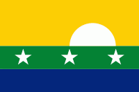
The Nueva Esparta State (in Spanish: Estado Nueva Esparta, ), is one of the 23 states of Venezuela. It comprises Margarita Island, Coche, and the largely uninhabited Cubagua.

The state has the smallest area, and is located off the northeast Caribbean coast of Venezuela. It is the only insular state of Venezuela (not including the Federal Dependencies, a federal territory but not a state). The main island of Margarita has an area of 1,020 km2. Its capital city is La Asunción, and the main urban center is Porlamar.

Its name, Nueva Esparta ("New Sparta"), comes from the heroism shown by its inhabitants during the Venezuelan War of Independence, deemed similar to that of the Spartan soldiers of Ancient Greece.

 
Map - Nueva Esparta (Estado Nueva Esparta)
Map
Google Earth - Map - Nueva Esparta
Google Earth
Openstreetmap - Map - Nueva Esparta
Openstreetmap
Map - Nueva Esparta - Esri.WorldImagery
Esri.WorldImagery
Map - Nueva Esparta - Esri.WorldStreetMap
Esri.WorldStreetMap
Map - Nueva Esparta - OpenStreetMap.Mapnik
OpenStreetMap.Mapnik
Map - Nueva Esparta - OpenStreetMap.HOT
OpenStreetMap.HOT
Map - Nueva Esparta - OpenTopoMap
OpenTopoMap
Map - Nueva Esparta - CartoDB.Positron
CartoDB.Positron
Map - Nueva Esparta - CartoDB.Voyager
CartoDB.Voyager
Map - Nueva Esparta - OpenMapSurfer.Roads
OpenMapSurfer.Roads
Map - Nueva Esparta - Esri.WorldTopoMap
Esri.WorldTopoMap
Map - Nueva Esparta - Stamen.TonerLite
Stamen.TonerLite
Country - Venezuela
Currency / Language  
ISO Currency Symbol Significant figures
VES Venezuelan bolívar BsS. or Bs. 2
ISO Language
ES Spanish language
Neighbourhood - Country  
  •  Brazil 
  •  Colombia 
  •  Guyana